
I was recently reading an essay by Sally Blundell called ‘Amending the Map’ about the Christchurch landscape after the earthquakes. It’s also available online. She talks about the earthquakes exposing an older landscape – “a landscape instrumental to telling the story of migration and settlement of early Maori … the subsequent history of cultural encounter and the physical and social development of the city” (Griffith Review, 43, p. 248).
I was reminded of my first job at Heritage New Zealand which was to research the heritage of the mostly rural area to the west of Wellington. The two small villages of Makara and Makara Beach bound the area I looked at, but I excluded these from the study and focussed only on the rural area. Terawhiti is a block of steep, rugged hill country on the south-west tip of the North Island, west of Wellington City. You don’t go through it to get to anywhere – many Wellingtonians would only know it by flying over it or seeing it from the ferry that sails between the North and South Islands. So what could possibly be of historical interest here?


The Terawhiti area has many ‘layers’ of history. It has been used for its various resources, and for particular aspects of its location and topography. Resource uses included the sea for fish and shellfish, the forest for birds and berries, and the land for farming and gold mining. Its location was important to Maori for viewing the sea conditions prior to crossing Raukawa (Cook Strait) and helping to control access to the northern end of Raukawa. During World War Two the high cliffs overlooking the Strait were used as a site for gun emplacements (with their associated camp buildings), and for a coast-watching station. Its rural, hilly, location near a major city made it a useful site for radio stations and for weather monitoring, and this combined with the consistent winds in the area have made it the site of a major wind farm for electricity generation in the 2000s.
Maori occupation and resource use may have begun as early as the fifteenth or sixteenth centuries, mostly in the coastal bays.


The headland was the site of Makara Pa (a Maori fortification) showing Mana and Kapiti Islands in the distance.
The name Terawhiti comes from a misunderstanding when Captain Cook asked some Maori in Queen Charlotte Sound what the land across the strait was called and was told ‘te ra whiti’ (the ‘sun in the east’, or simply ‘the east’).[1] ‘Teerawitte’ was marked on Captain Cook’s 1770 chart of Cook Strait. Ohariu Bay was an important landing place for all canoes visiting Wellington (or Te Whanganui a Tara which is the Māori name for Wellington Harbour) from the South Island and west coast of the North Island.[2] A track led over the hills to near Kaiwharawhara on the harbour – this continued to be used into the early years of European settlement.
Since the 1840s the area has been farmed by European settlers and their descendants. Terawhiti Station and the associated Te Kamaru and Te Marama Stations also provide an unusual example of reasonably large farming stations close to a major city. At times, flocks of sheep were driven through Wellington streets.

Terawhiti Station in 1909 [The McMenamen homestead, Terawhiti, during the search for survivors from the Penguin. Smith, Sydney Charles Ref: 1/1-020149-G. Alexander Turnbull Library, Wellington.]
Gold mining
At times from the 1850s it was also the site for gold prospecting – it is Wellington’s (and the lower North Island’s) only example of a large area that includes a range of gold-related sites including tunnels, tracks, mines, tramways, tailings, stores and house sites. The gold mining claims were leased from private farm owners.
The discovery in 1881 of gold-bearing quartz on Black Mountain (Terawhiti Hill) led to the most substantial period of mining at Terawhiti. Many companies formed in the next few years, but only a few expended significant amounts of money and effort to find gold. Three were the Albion, the Phoenix and the Golden Crown. The Phoenix was the first to buy and install a quartz crusher patented by George Ashcroft of Petone. The Albion was the first company to stake its claim in the newly discovered western field. It also installed a quartz crushing battery in the Oteranga Valley (or Black Gully), which necessitated building a bullock road from the Oteranga Bay to the site; as well as a series of tramways and tunnels in order to get the ore from its mine 300 metres on the hill above the battery site. The Albion battery was only used for three crushings – the Golden Crown company used it for two of these and the Albion Company only once.


Albion Battery, Terawhiti, c. 1880s, Alexander Turnbull Library PA1-f-036-06, Photographer unidentified.
This is my annotated version of the photo above:

1. Battery house, 2. Wooden trestle leading from the building to the embankment, 3. Embankment to the right of the building. 4. Tunnel mouth. 5. Incline tramway. 6. The windlass, which was over the mine shaft, and is just visible on the horizon at the top of the hill to the right of the incline tramway.
The Albion Battery Remains have been listed as a Category 2 historic place by Heritage New Zealand – information about it from the report I wrote can be found here. Please note it is on private land and permission is needed to visit.

There was ‘gold fever’ in the early 1880s in Wellington, as shown by frequent newspaper reports, the use of Pigeon Express (carrier pigeon) to bring news from the mines, and in activities such as the Wellington Amateur Dramatic Club’s performance of ‘The Very Witty Diggings’ on 18 February 1881. The government steamer Hinemoa also took many members of both Houses of Parliament on an excursion to the gold fields on 11 August 1883. A post office was opened there in October 1883 – it survived until early 1885. By 1882, Makara resident Wilhelm Sievers had built additions to his house for accommodation and for selling alcohol, calling it The Miners’ Arms. This building was demolished in 1977 as the land is now owned and used by the Karori Golf Club.
Fred Dowsett also supplied the mines with bread and groceries. He built a store on the gold fields, which was completed in mid-August 1883. It is not known how long his store operated but he said he lost over ₤1000 from the venture. Terawhiti station also sold meat to the miners. (The best source on the gold mining is James Brodie, Terawhiti and the Gold Fields, Karori Historical Society (Inc), Wellington, 1986 (reprinted 2000).)
Shipwrecks
The rocky coast, strong winds, tidal rips and fog that occur in the area have caused at least 15 recorded shipwrecks from 1842 to 1909 around the Terawhiti coastline (from Sinclair Heads to Ohau Bay). The most well-known was the Penguin in February 1909, with the loss of 72 people.[3] As a result of the Penguin tragedy, an unmanned light was eventually built on Karori Rock.
Of the 30 survivors, only one was a woman – Mrs Ada Hannam, who was called the heroine of the wreck.[4] She lost her husband and four children in the wreck, but she saved the life of a 17 year old boy, and tried, unsuccessfully, to save her youngest child by tying her to the lifeboat seat. Ada and the boy Ellis Matthews were actually under the lifeboat as it washed ashore and were not rescued until daylight when a voice was heard from under the boat. Later the same day she borrowed a horse and rode over the hills to Makara where a car took her to Wellington. She was pregnant at the time.
Communication and energy uses
Oteranga Bay on the south coast has been the North Island terminus site for telegraph cables and since 1965 for the Cook Strait power cable. The area in the north called Quartz Hill was acquired by the Crown in 1942 for Post and Telegraph purposes, which ran a radio receiving station. Another was also run by the Broadcasting Corporation. The most recent development here and on Terawhiti Station has been the erection of 62 wind turbines by Meridian Energy.
Access
The area’s hilly topography has meant that land access has been difficult for much of its human occupation. Access by sea was important for Maori. Coastal shipping was also important for the European farmers for getting supplies in and wool exports out. The heavy gold-mining equipment in the nineteenth century and the recent wind turbines were also shipped in.
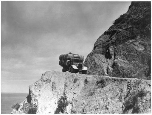
Taking out wool from Terawhiti Station (previously it was shipped out). The truck of H W Thomas Ltd carrying wool bales on a steep coastal road, Cape Terewhiti [sic] Taken by E P Christensen c. 1939. Alexander Turnbull Library Ref: MNZ-1667-1/2-F. (According to an article in Karori News, 11 Jan 1978, the truck is descending from Tongue Point to the Karori stream mouth, where it worked its way up near the Karori stream to South Makara Road, fording the stream more than 30 times.)
Recreational uses
The area is popular with trampers, walkers doing the six kilometre Makara Walkway, and for fishing around the coastline. Cook Strait swimmers from the 1960s onwards left or arrived at Ohau Bay. The artist Nugent Welch was a well-known frequent visitor to the area from the late 1920s. In the early 1930s he began using a cave on the south coast just to the west of Oteranga Bay to stay in while he sketched and painted. It is often referred to as ‘Nugent’s cave’. [5] The year before his death in 1970 (his ashes were scattered at Cape Terawhiti) Nugent Welch wrote:
‘What wonderful country for the tramper, and speaking from the stand point of a painter I never found a stretch of coast line to surpass it.’[6]

Nugent Welch at Terawhiti, taken by Frank Fitzgerald, possibly in the ’50s, and printed by Karen Lee about 2002; and two of his watercolours of the area. Top Image: Evening, Oteranga, Victoria University Collection. Lower image: Calm Morning, Terawhiti, Te Papa Collection.


For information about the Makara Home Guard in World War Two click on this recent (2017) blog post written by Lemuel Lyes.
Footnotes
[1] G Leslie Adkin, (1959) The Great Harbour of Tara, Whitcombe & Tombs, p. 85.
[2] Tony Walzl, ‘Ngati Tama in Wellington, 1820–1920’, Wai 145#H7 Record of Inquiry, Waitangi Tribunal, Wellington, May 1997, p. 12.
[3] The fullest account of the Penguin shipwreck is in Bruce Collins, The Wreck of the Penguin, Wellington: Steele Roberts, 2000. The number of dead is often said (mistakenly) to be 75.
[4] For example, in ‘The Heroine of the Wreck’ Hawera and Normanby Star, 17 February 1909, p. 5
[5] Leo Fanning, ‘He’s a cheerful bachelor of arts’, Evening Post, 13 Sept 1958
[6] Letter of 28 Nov 1969; copy on Te Papa library artist file on Nugent Welch

Yay for Mrs Ada Hannam … what a poignant, heroic and tragic tale … What happened to her and the lad she saved?
LikeLike
In the 1930s she was living in Auckland with the son who was born 6 months after the shipwreck – he was an officer on a steamer, and she was still Mrs Hannam, so presumably never remarried. She hadn’t seen Ellis Matthews since the wreck but understood he was married & living in Blenheim. (From two newspaper reports: Auckland Star, 12 February 1930, Page 3; & 22 April 1938, Page 9).
LikeLike
My step father Les Ritchie worked on Terawhiti Station as shepherd, post World War 2 and prior to my Mum Edna (Brogden/Burgess) marrying him.
I have awesome childhood memories of Terawhiti Station from about 1956/57 after Les had moved on from Terawhiti and purchased his family farm at Ngumu east of Masterton. Les, Mum, my two brothers Garry, Tony and I were lucky enough to revisit the Station for about three or four family Christmas camps mid to late 1950s.
I remember the long winding track/road in, all the creek crossings, awesome fishing, the loan of a Willys Jeep, the drama of Les parking the truck on the terraces above the bluffs, getting out to check how Mum was coping in the family car with the kids, coming along behind, to discover that all the creek crossings had wet the trucks drum brakes, the hand brake failed to hold and the truck took off down the hill and over the cliff to the beach far below. As far as I remember the truck was never retrieved. But the adults climbed down the bluffs to rescue all the camping gear by rope.
The Fink family also camped at Terawhiti in a bach as far as I remember.
LikeLiked by 1 person